Community Guide · St. Francois County

Park Hills, Missouri

Old Lead Belt history, established neighborhoods, Central R-III schools, and nationally distinctive off-road recreation.

Kyle Weiss
Kyle’s Local Take

Park Hills was formed in 1994 through the consolidation of four historic Lead Belt mining towns—Flat River, Elvins, Esther, and Rivermines—plus the later annexation of Frankclay. Because of this merger, it is physically the largest municipality in St. Francois County, spanning over 20 square miles. The city is famous as the home of St. Joe State Park and the Missouri Mines State Historic Site, making it a premier regional destination for off-road vehicle (ORV) enthusiasts, campers, and outdoor adventurers. Housing is diverse and affordable: turn-of-the-century craftsman bungalows and historic mining homes in the old neighborhood centers, mid-century ranches on generous lots, and newer construction along the U.S. 67 and Route 32 corridors. Students attend the Central R-III School District (Rebels). Due diligence priorities include city occupancy inspections, checking historic mining soil remediation status, and scoping older sewer lines.

Park Hills at a glance

A practical orientation before comparing properties

COMMUNITY TYPEIncorporated city · consolidated Lead Belt anchor
2025 POPULATION ESTIMATE8,589
MEDIAN HOUSEHOLD INCOME$46,522
MEDIAN OWNER-OCCUPIED VALUE$139,400
LAND AREA20.35 square miles
GENERAL TRAVEL TO DOWNTOWN ST. LOUIS60–70 minutes via US 67 and I-55
Community character, housing, and commute

What daily life and property ownership look like here

A central Old Lead Belt city created from former mining communities, with college, civic, and park access. Older mining-era housing, brick homes, ranches, subdivisions, apartments, and rural edges.

Primary regional access is through US 67 and Route 8. Downtown St. Louis is roughly 65–80 minutes; peak traffic and the first miles on local roads can change the practical trip.

Former mining land and older housing create distinct due-diligence questions Condition, utilities, drainage, and exact municipal location vary

Neighborhood pockets

Park Hills changes noticeably from one corridor to another

Main Street · Taylor Avenue · Flat River Drive · Historic commercial core

Flat River historic core and Main Street

Older cottages, bungalows, craftsman homes, and a traditional street grid around local businesses and civic uses.

Daily-life advantage: Walkable access to downtown services and community activity at accessible price points.

Rebel Drive · High Street · School campus loop · West Elementary area

Central R-III campus area

Ranches, split-levels, and established neighborhoods close to school campuses and athletic facilities.

Daily-life advantage: Short access to district activities, sports, and daily school travel.

Elvins Boulevard · Rivermines area · Park-boundary drives · Frankclay fringe

Elvins and St. Joe gateway

Single-family homes, workshops, garages, and larger properties positioned near the state-park entrance and outer city terrain.

Daily-life advantage: Very quick access to off-road riding and outdoor recreation, with storage and access needs that vary by property.

Things to do and everyday life

Local places around Park Hills

Pimville Road

St. Joe State Park

A major state park with a large designated off-road vehicle area, campgrounds, lakes, trails, equestrian facilities, and paved cycling.

St. Joe State Park complex

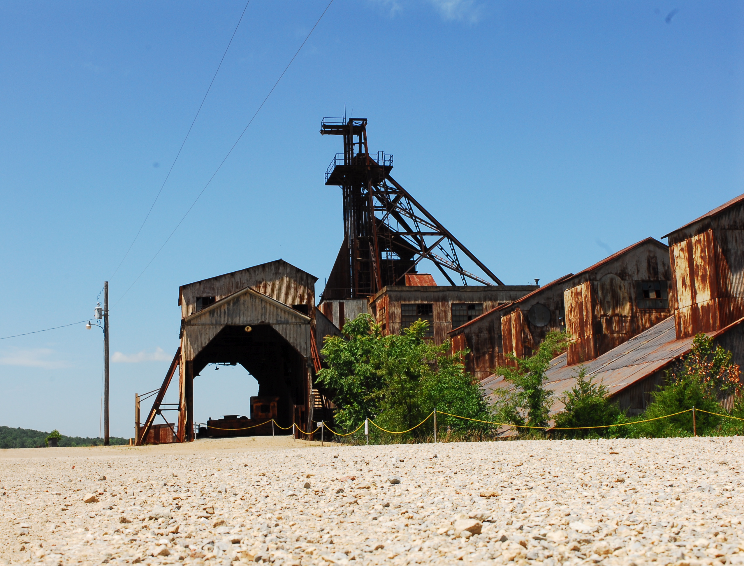
Missouri Mines State Historic Site

A museum and historic mill complex interpreting the machinery, minerals, labor, and industrial history of Missouri’s Old Lead Belt.

343 West Main Street

Four Towns Brewing Company

A locally operated brewery and taproom in the historic Flat River area. Review the current tap list, food options, events, and opening hours.

Local services and institutions

Who serves Park Hills

MUNICIPAL GOVERNMENT

City of Park Hills

  • 9 Bennett Street · 573-431-3577
  • Administration, municipal court, permits, occupancy, water, and sewer information
PUBLIC SCHOOLS

Central R-III School District

  • District office: 573-431-2616
  • Central High, Middle, Primary, and West Elementary campuses
  • Confirm attendance from the exact address
POLICE, FIRE & EMS

Park Hills public safety

  • Park Hills Police dispatch: 573-431-3122
  • Park Hills Fire Department through City Hall
  • St. Francois County Ambulance District: 573-431-0030
UTILITIES

City and regional providers

  • Ameren Missouri · electric
  • Spire · natural gas where available
  • City water and sewer in served areas
  • Confirm trash, recycling, deposits, and account transfer
LIBRARY & CIVIC

Park Hills resources

  • Park Hills Public Library
  • Municipal events and neighborhood facilities
  • Central R-III and nearby Mineral Area College programming
CONNECTIVITY

US 67 and Routes 8/32

  • US 67 provides north–south regional access
  • Routes 8 and 32 connect eastern and western county destinations
  • The city covers a large, varied municipal footprint

School attendance, emergency-response district, utility territory, and jurisdiction may vary within a mailing area. Confirm the organizations serving a specific property by address.

Buyer due diligence

Four Park Hills details worth resolving before closing

Municipal occupancy requirements

Park Hills may require residential inspection and approval before transfer or occupancy.

What to do: Confirm the current application, fee, checklist, repair responsibility, and reinspection process directly with the city.

Consolidated utility footprints

Water, sewer, pressure, line age, and infrastructure can vary among the former community areas.

What to do: Identify the exact provider, service line, account status, and utility records for the parcel.

Historic mine and soil conditions

Mining, chat, tailings, industrial uses, and remediation are part of the region’s documented history.

What to do: Review current property-specific environmental records and disclosures from authoritative agencies.

Older sewer laterals

Historic and mid-century homes may retain clay or other older lines affected by roots, settlement, or prior repairs.

What to do: Order a camera scope and document material, route, cleanouts, condition, and responsibility to the main.

Related communities

Compare other places in St. Francois County

Common questions

Park Hills questions buyers commonly ask

Is every Park Hills mailing address inside the same jurisdiction?

Not necessarily. Postal names can extend beyond city limits, so city and county responsibilities may differ by parcel.

How long is the drive to downtown St. Louis?

Use roughly 65–80 minutes as a general orientation. The exact starting point, destination, traffic, and local-road portion determine the actual trip.

Which school district serves the area?

Central R-III. Attendance boundaries can split a mailing area, so the property address controls the assignment.

What housing is common?

Older mining-era housing, brick homes, ranches, subdivisions, apartments, and rural edges.

What local tradeoffs matter most?

Former mining land and older housing create distinct due-diligence questions Condition, utilities, drainage, and exact municipal location vary

References
U.S. Census Bureau data for Park Hills, MissouriCity of Park Hills, MissouriCentral R-III School DistrictMissouri State Parks: St. Joe State ParkMissouri Mines State Historic SiteFour Towns Brewing CompanySt. Francois County governmentU.S. Census BureauRegional visitor and local-business directoryMissouri DESE directoryFCC National Broadband Map
Talk to Kyle

Thinking about making a move?

Start with the question you have today. No pressure and no generic sales pitch.

Prefer to talk now?