Community Guide · St. Charles County

Augusta, Missouri

Historic wine-country streets, Missouri River bluff scenery, rural acreage, and Katy Trail access along Route 94.

Kyle Weiss
Kyle’s Local Take

Augusta has a prominent place in American wine history: the Augusta AVA, approved in 1980, was the nation’s first federally recognized American Viticultural Area. The incorporated town is compact, with historic brick and frame buildings, tasting rooms, inns, and local events, while the broader Augusta mailing area extends into vineyards, farms, wooded ridges, and custom acreage homes. That setting is a major part of the appeal, but it also changes the inspection plan. Buyers should confirm town limits, school district, water and wastewater service, well and septic records, recorded restrictions, legal access, bluff drainage, and lower-ground flood exposure for the actual parcel.

Augusta at a glance

A practical orientation before comparing properties

COMMUNITY TYPEIncorporated town · Augusta AVA core
2020 CENSUS POPULATION293
MEDIAN HOUSEHOLD INCOMEUse current Census profile · small-sample estimate
MEDIAN OWNER-OCCUPIED VALUEUse current Census profile · small-sample estimate
LAND AREAAbout 0.94 square miles
GENERAL TRAVEL TO DOWNTOWN ST. LOUIS50–65 minutes via Route 94 and I-64 · estimated
Community character, housing, and commute

What daily life and property ownership look like here

A small Missouri River hill town in wine country with historic buildings, rural roads, and Katy Trail access. Historic cottages, rural homes, vineyards, acreage, and custom properties.

Primary regional access is through Route 94 and local river-hill roads. Downtown St. Louis is roughly 50–70 minutes; peak traffic and the first miles on local roads can change the practical trip.

Route 94 is scenic but indirect for daily metro travel Steep terrain, wells, septic, tourism traffic, and property access deserve review

Neighborhood pockets

Augusta changes noticeably from one corridor to another

Walnut Street · Chestnut Street · Jackson Street · Hackmann Street

Historic town grid

Historic brick and frame homes, inns, tasting rooms, civic buildings, and compact lots in a walkable street pattern.

Daily-life advantage: Close access to local businesses, seasonal events, and the wine district, with preservation and tourism considerations.

Route 94 · Katy Trail approaches · Klondike-area ridge roads

River bluffs and trail approaches

Custom homes, wooded lots, and elevated properties above the Missouri River valley.

Daily-life advantage: Views and outdoor access balanced against slope, drainage, road geometry, and lower-access flood conditions.

Route T · Femme Osage area · Western county roads

Vineyard and rural acreage

Farms, equestrian properties, vineyards, outbuildings, and multi-acre residential tracts.

Daily-life advantage: Land and privacy with private-system, maintenance, and recorded-use questions to resolve.

Things to do and everyday life

Local places around Augusta

Missouri River valley below town

Katy Trail State Park — Augusta trailhead

A local access point to Missouri’s long-distance rail trail for bicycling and walking. Check trail closures, flood conditions, parking, and seasonal services.

5601 High Street

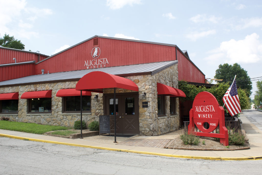
Augusta Winery

A long-running Augusta tasting room and wine producer. Confirm current hours, live-music schedules, food policies, and group arrangements.

5634 High Street

Mount Pleasant Estates

A historic winery property with tastings, food, views, and scheduled events. Review current operating details before visiting.

Local services and institutions

Who serves Augusta

TOWN & COUNTY GOVERNMENT

Town of Augusta and St. Charles County

  • Town administration · 232 Jackson Street
  • St. Charles County government and parcel records
  • Confirm jurisdiction, zoning, permits, and roads by parcel
PUBLIC SCHOOLS

Address-dependent districts

  • Washington and Francis Howell district boundaries may apply in the broader area
  • Confirm attendance and transportation directly from the exact address
POLICE, FIRE & EMS

County and district services

  • St. Charles County Police: 636-949-3000
  • Augusta Fire Protection District
  • St. Charles County Ambulance District: 636-344-7600
UTILITIES

Town, cooperative, and private systems

  • Ameren Missouri or Cuivre River Electric depending on address
  • Confirm town water service where available
  • Private well, wastewater, propane, and trash service may apply
  • Verify broadband at the service address
CONNECTIVITY

Route 94 and rural roads

  • Route 94 connects Defiance and I-64
  • Route T and county roads serve rural property
  • Test travel during events and winter weather
WINE & TRAIL DISTRICT

Current operations vary

  • Augusta AVA wineries and tasting rooms
  • Katy Trail access
  • Confirm hours, reservations, events, parking, and seasonal closures

School attendance, emergency-response district, utility territory, and jurisdiction may vary within a mailing area. Confirm the organizations serving a specific property by address.

Buyer due diligence

Four Augusta details worth resolving before closing

Town limits and service boundaries

An Augusta mailing address may lie outside the incorporated town and use different services or regulations.

What to do: Verify jurisdiction, taxes, schools, fire and ambulance districts, utilities, roads, and permits from the parcel record.

Private wells and wastewater

Rural properties may rely on private wells and on-site wastewater in clay and limestone-influenced terrain.

What to do: Review permits and logs, test water and sustained flow, and inspect the actual wastewater system and reserve area.

Route 94 tourism and cycling traffic

Winery events and trail use can change weekend traffic, parking, sound, and turning conditions.

What to do: Visit during representative weekends and evenings and test the exact route to the property.

Bluff and river-bottom conditions

Slope, drainage, retaining, erosion, and flood exposure can differ sharply across short distances.

What to do: Review survey, topography, FEMA mapping, drainage, access history, insurance, and structural conditions.

Related communities

Compare other places in St. Charles County

Common questions

Augusta questions buyers commonly ask

Is every Augusta mailing address inside the same jurisdiction?

Not necessarily. Postal names can extend beyond city limits, so city and county responsibilities may differ by parcel.

How long is the drive to downtown St. Louis?

Use roughly 50–70 minutes as a general orientation. The exact starting point, destination, traffic, and local-road portion determine the actual trip.

Which school district serves the area?

Washington; Francis Howell in portions of the broader area. Attendance boundaries can split a mailing area, so the property address controls the assignment.

What housing is common?

Historic cottages, rural homes, vineyards, acreage, and custom properties.

What local tradeoffs matter most?

Route 94 is scenic but indirect for daily metro travel Steep terrain, wells, septic, tourism traffic, and property access deserve review

References
Town of Augusta, MissouriU.S. Census Bureau data for Augusta, MissouriAlcohol and Tobacco Tax and Trade Bureau: Augusta AVAMissouri State Parks: Katy TrailAugusta WineryMount Pleasant EstatesSt. Charles County governmentSt. Charles County governmentU.S. Census BureauRegional visitor and local-business directoryMissouri DESE directoryFCC National Broadband Map
Talk to Kyle

Thinking about making a move?

Start with the question you have today. No pressure and no generic sales pitch.

Prefer to talk now?